Posts

Image
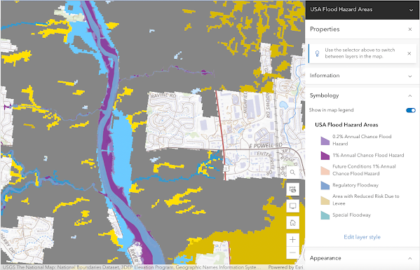
Flood Plain Map of the Olentangy River Watershed   The map I created is of the Olentangy River watershed. I chose the area near the upper portion of the river before it reached the city of Columbus. I was interested in this specific location because of its geological formation. This area has cuffs and changes in elevation, which is different from most of the city of Columbus, so I was interested in seeing how flooding could affect the area. Since many tributaries flow into the river at this I wanted to see how that would potentially affect flooding in the area.  I also wanted to add a couple of maps that I found on FEMAs website that were interesting to me. I chose these maps because one is on the upper portion of the river while the other focuses on the confluence of the Olentangy river and the Scioto river. this was interesting to me because of how the meeting of the two rivers could potentially affect flooding around the city. 

Agriculture on the Olentangy river

Image
Threats to the Olentangy Watershed Major Threat:   Agriculture The Olentangy River watershed is significantly impacted by agricultural activities. Runoff from farms, including fertilizers, pesticides, and animal waste, enters the river system, contributing to water pollution. These pollutants can lead to nutrient enrichment, algal blooms, and contamination of the water, affecting both aquatic life and the overall ecosystem. Sedimentation from erosion caused by agriculture also degrades water quality and habitats within the watershed. Efforts to mitigate these impacts include implementing best management practices (BMPs) on farms, improving land use planning, and promoting sustainable agricultural practices to reduce pollution and protect the Olentangy River watershed.    Using the waterway tools from the EPA, it is noted that the mouth of the river is impaired mainly by agricultural run-off. This run-off mainly consists of Nitrogen and Phosphorus. Above are annual amounts of nutrients
Image
Watershed Characteristics   Some of the major characteristics of the Olentangy River Watershed include:  Flowing through downtown Columbus, Ohio Geology:  Three geological regions  Upper, middle, and lower Much of the geology of the watershed is influenced by glaciers that used to mover through the area The entire upper region is now agricultural area The middle region consists of limestone bed rock, a flood plane in the western part of the river and has a pretty consistent width of 40-50 feet The lower region is where the confluence to the Scioto river is located, it is also broader and deeper and has been back filled with silty alluvium and glacial outwash. Land-use:  Agricultural  Deciduous forest Evergreen forest Mixed forest Pasture                                                                                                 Rangeland  Commerical High density residential  Low density residential  Forested wetland  Emergent wetland Aquatic Life: Some of the most important organis

Delineating my Watershed: The Olentangy River Watershed

Image